Photos
Tinks's GPS commentary
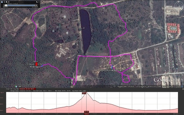
Yesterdays runners trail for me was around 3.4 km in 46:21 min. Elevation - Min 24 m Max 100 m, Gain 103 m, Loss 103 m, Max slope - Ascent 39.0%, Descent 34.4%. Route went clockwise Distance to R/W Split was 1.6 km and took me 22:28 min Runners loop 1.8 km in 23:53 min The R/W split was at the highest point and then Walkers went left and completed their trail in an anti-clockwise direction Total No of Hashers – 46
Tinks's GPS commentary
Yesterdays runners trail for me was around 3.4 km in 46:21 min. Elevation - Min 24 m Max 100 m, Gain 103 m, Loss 103 m, Max slope - Ascent 39.0%, Descent 34.4%. Route went clockwise Distance to R/W Split was 1.6 km and took me 22:28 min Runners loop 1.8 km in 23:53 min The R/W split was at the highest point and then Walkers went left and completed their trail in an anti-clockwise direction Total No of Hashers – 46
Rabid Dogs shorten Hash Trail
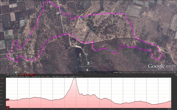
Hash # 280 off Soi 102 was so close to town it was quite surprising that we were actually very close to the hills, and that 69 forever was late again! Brambles and Jock Twat regaled us at length with stories of Rabid dogs necessitating the sever shortening of the trail but finally off we went, and in no time at all we were deep into our beloved Thai countryside, surrounded by familiar mountain scenery. The runners were soon strung out ahead of us toiling up what turned out to be a very steep hill, when the walkers arrived at the base.
Click on Read More for the rest of the story
 RSS Feed