
Hash Notes by Tinks
Hash Photos by Tinks
Relive Video of Walkers Trail by Tinks.
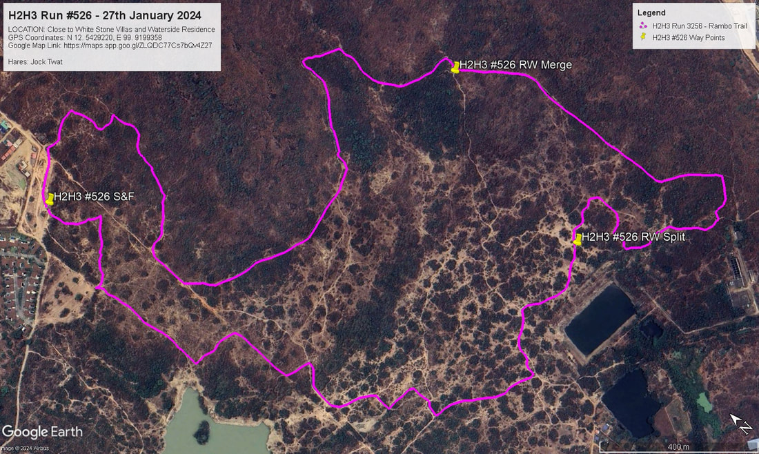
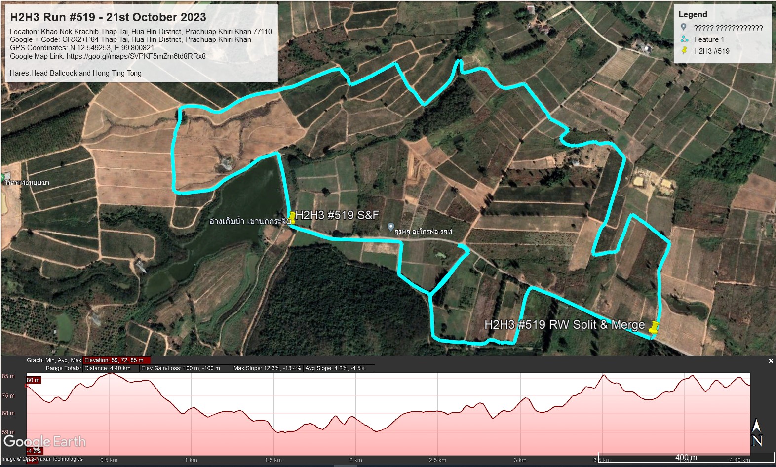
GPS Image of Trails set by Hong Ting Tong, African Queen, and Flying Frog.
Walkers (Cyan) Trail according to my GPS was 5.4 km in a moving time of 74:50 minutes.
Elevation: Min 30 m, Max 64 m, Gain/Loss 95 m.
Maximum Slope: Ascent 15.2%, Descent 17.6%.
Start to RW Split: 3.9 km. in 55.37 min.
RW Split to RW Merge: 0.65 km. in 14:15 min.
RW Merge to Finish: 0.4 km. in 4.58 min.
Rambo (Yellow) Trail according to Bite Mark GPS was 7.5 km in a moving time of 70:14 mins. (Note: This excludes the first 770 metres, so the Rambo trail was close to 8.3 km)
Elevation: Min 30 m, Max 92 m, Gain/Loss 172 m.
Maximum Slope: Ascent 24.2%, Descent 24.8%.
Start to RW Split: 3.9 km. in 33.23 min.
RW Split to RW Merge: 3.2 km. in 34.25 min.
RW Merge to Finish: 0.4 km. in 2.26 min.
The trails went anti-clockwise.
On On Tinks
Hash Photos by Tinks
Relive Video of Walkers Trail by Tinks.
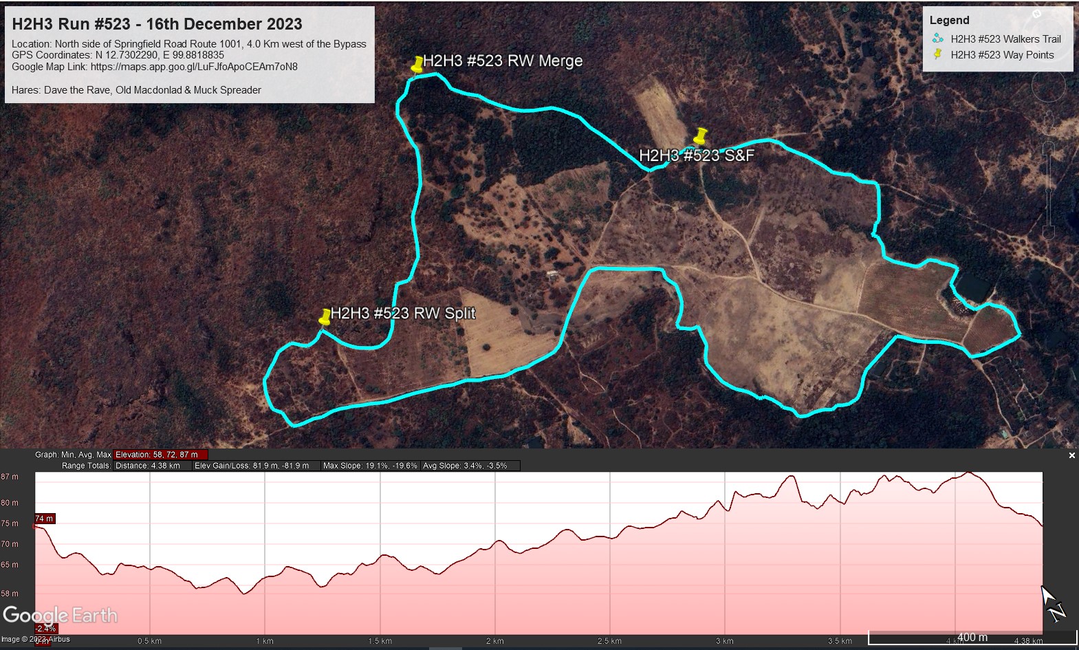
GPS Image of Trails set by Hong Ting Tong, African Queen, and Flying Frog.
Walkers (Cyan) Trail according to my GPS was 5.4 km in a moving time of 74:50 minutes.
Elevation: Min 30 m, Max 64 m, Gain/Loss 95 m.
Maximum Slope: Ascent 15.2%, Descent 17.6%.
Start to RW Split: 3.9 km. in 55.37 min.
RW Split to RW Merge: 0.65 km. in 14:15 min.
RW Merge to Finish: 0.4 km. in 4.58 min.
Rambo (Yellow) Trail according to Bite Mark GPS was 7.5 km in a moving time of 70:14 mins. (Note: This excludes the first 770 metres, so the Rambo trail was close to 8.3 km)
Elevation: Min 30 m, Max 92 m, Gain/Loss 172 m.
Maximum Slope: Ascent 24.2%, Descent 24.8%.
Start to RW Split: 3.9 km. in 33.23 min.
RW Split to RW Merge: 3.2 km. in 34.25 min.
RW Merge to Finish: 0.4 km. in 2.26 min.
The trails went anti-clockwise.
On On Tinks

 RSS Feed