
Hash Notes by Adam's Apple
Photos by Pedalphile
GPS scan by Hugmanannygoat
GPS scan by Tinks
Commentaries on GPS scans by Tinks and Hugmanannygoat - click on Read More
Photos by Pedalphile
GPS scan by Hugmanannygoat
GPS scan by Tinks
Commentaries on GPS scans by Tinks and Hugmanannygoat - click on Read More
Hugmanannygoat
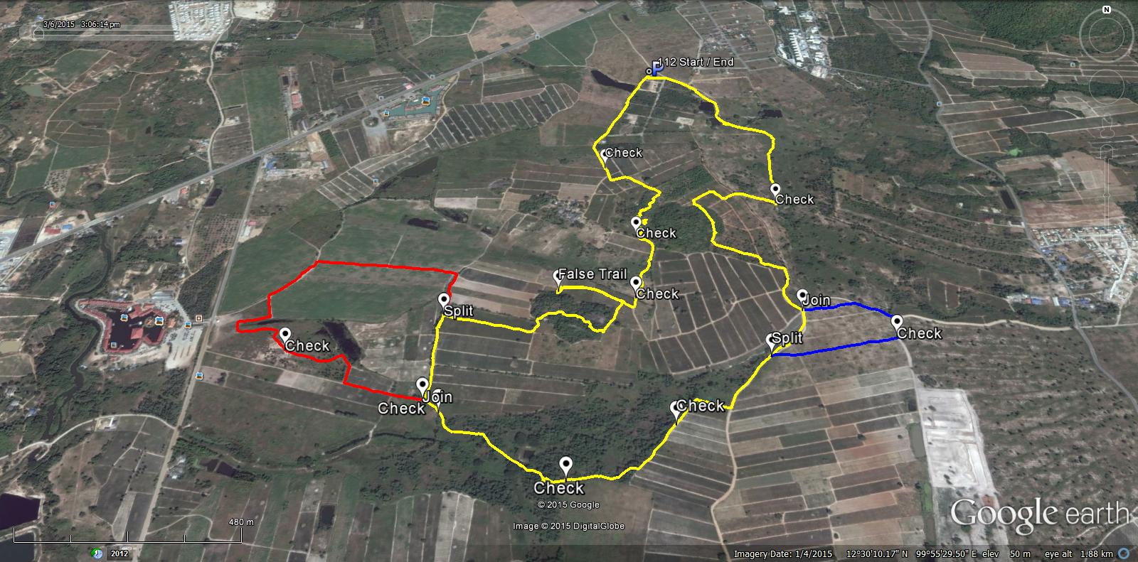
Saturday's trail offered a variety of options. There were 2 splits both with an option of Long or Short trails. Each hasher therefore had an option to take a Long option plus another Long option, a Short option followed by another Short option, a Short and a Long option or a Long and a Short option. You will see by the attached map the second Long trail was shorter than the first Long trail and even the Short Short trail was quite Long. The map shows yellow depicting the Short, Short option which includes the False trail. The first Long option is depicted in Red and the second Long option is depicted in Blue.
The Long Long trail was 7.1Km.
The Long Short trail was 6.6 Km
The Short Long trail was 5.9 Km
The Short Short trail was 5.4 Km
Add 0.4 Km if you went on the False Trail.
That's about the Long and the Short of it.
Thanks to Jock Twat and Mudman for helping with the On-After venue which turned out to be very entertaining and enjoyable. Looking forward to the photos from Hash Flash Pedalfile.
The route went anti-clockwise
Hugmanannygoat's afterthoughts
Afterthought hash notes: I was told by Merrydick that there wasn't any sign for the first split and Screwdriver informed me that some "walkers" went on the runners trail. There was a sign for the split, but the reason some missed it and ended up on the runners trail can be explained. If you look at the attached map, after the false trail, the trail goes through woodland and exits on to open fields. At this point it was possible / likely hashers could spot FRB's in the field below, so instead of following the paper, they cut down to follow the runners, thereby missing the split sign and ending up on the Long Trail. A classic example of shortcutters ending up on the runners trail!
Also, if you look at the attached map you will see where the check before the False Trail was situated. Some said the check didn't exist, but if you compare the attached map with Tink's map, you will see Tinks turned left after the check, (because there was no paper to follow), showing strong evidence that the check did exist but was not spotted.
Tinks
Yesterdays Hash runners trail for me was 7.1 km in 81:53 min.
Elevation - Min 28 m Max 66 m, Gain/Loss 91 m.
Max slope - Ascent 8.2%, Descent 13.0%.
Route went anti-clockwise
Distance to R/W Split 1: 2.1 km
Runners Loop 1 : 1.6 km
R/W Merge 1 to R/W Split 2: 1.1 km
Runners Loop 2: 0.6 km
R/W Merge 2 to Finish: 1.7 km
 RSS Feed
.jpg)