
Hash Notes by Tinks
Photos by Hugmanannygoat
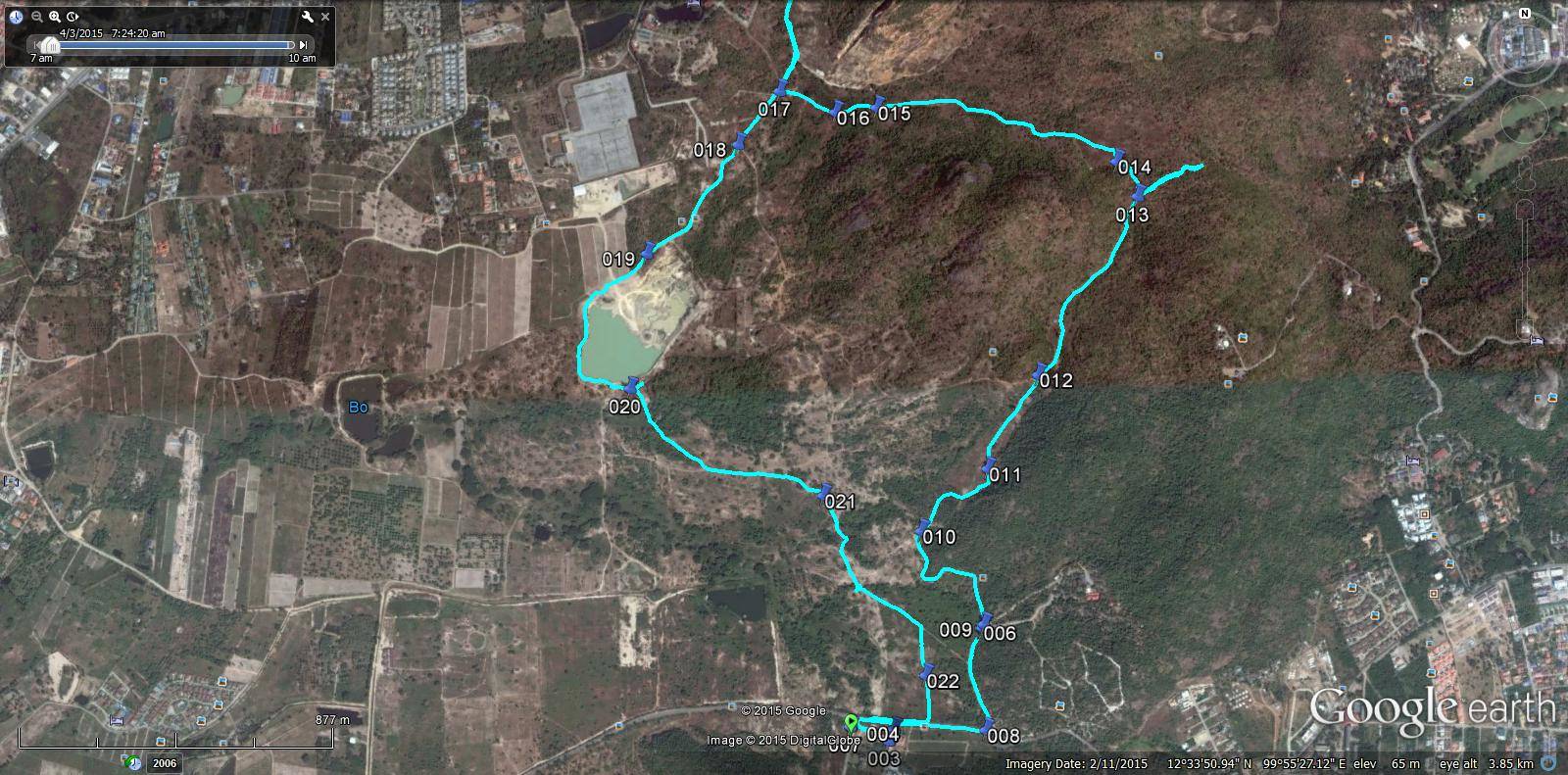
GPS scan of trail as planned by Jock Twat
with acknowledgement to Hugmanannygoat for loan of GPS and finalisation of scan and details
004 - Car park.
012 > 021 Short walk.
013 - 1st false trail.
017 - 2nd false trail.
018 - Walkers/runners split.
018, 019, 020 & 021 - Runners loop.
021 - Walkers/runners join.
Sort walk 4.2km
Long walk 5.9km
Run 6.7km
Run with false trails 7.6km
Hugmanannygoat's tribute to stand-in hare Scotch Tape with his response
GPS scan by Tinks
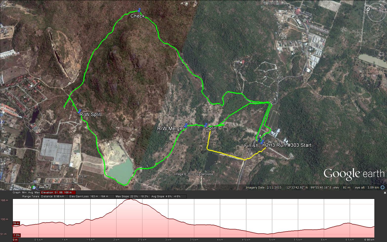
Last Saturdays Hash trail (Green JT’s trail) for me was 7.0 km in 81:13 min.
Elevation - Min 51 m Max 168 m, Gain/Loss 163 m.
Max slope - Ascent 22%, Descent 18.2%.
Route went anti-clockwise
Distance to Check at top of the hill 1: 2.4 km.
Distance to R/W Split: 4.0 km.
Runners Loop (R/W Split to Merge): 1.6 km
R/W Merge to Finish: 1.4 km
Apparently the trail split right (Yellow Trail – ST’s Trail) and should have been followed.
Distance from split to Finish: 950 m.
If I had followed the correct trail like some (Bush Whacker for one) then the total runners trail would have been 6.85 km, 150 m shorter.
Photos by Hugmanannygoat
GPS scan of trail as planned by Jock Twat
with acknowledgement to Hugmanannygoat for loan of GPS and finalisation of scan and details
004 - Car park.
012 > 021 Short walk.
013 - 1st false trail.
017 - 2nd false trail.
018 - Walkers/runners split.
018, 019, 020 & 021 - Runners loop.
021 - Walkers/runners join.
Sort walk 4.2km
Long walk 5.9km
Run 6.7km
Run with false trails 7.6km
Hugmanannygoat's tribute to stand-in hare Scotch Tape with his response
GPS scan by Tinks
Last Saturdays Hash trail (Green JT’s trail) for me was 7.0 km in 81:13 min.
Elevation - Min 51 m Max 168 m, Gain/Loss 163 m.
Max slope - Ascent 22%, Descent 18.2%.
Route went anti-clockwise
Distance to Check at top of the hill 1: 2.4 km.
Distance to R/W Split: 4.0 km.
Runners Loop (R/W Split to Merge): 1.6 km
R/W Merge to Finish: 1.4 km
Apparently the trail split right (Yellow Trail – ST’s Trail) and should have been followed.
Distance from split to Finish: 950 m.
If I had followed the correct trail like some (Bush Whacker for one) then the total runners trail would have been 6.85 km, 150 m shorter.
 RSS Feed